Pilot Applications
Among the various objectives in So2Sat, the following application areas are of great social impact to the humanity:
3D/4D urban infrastructure model
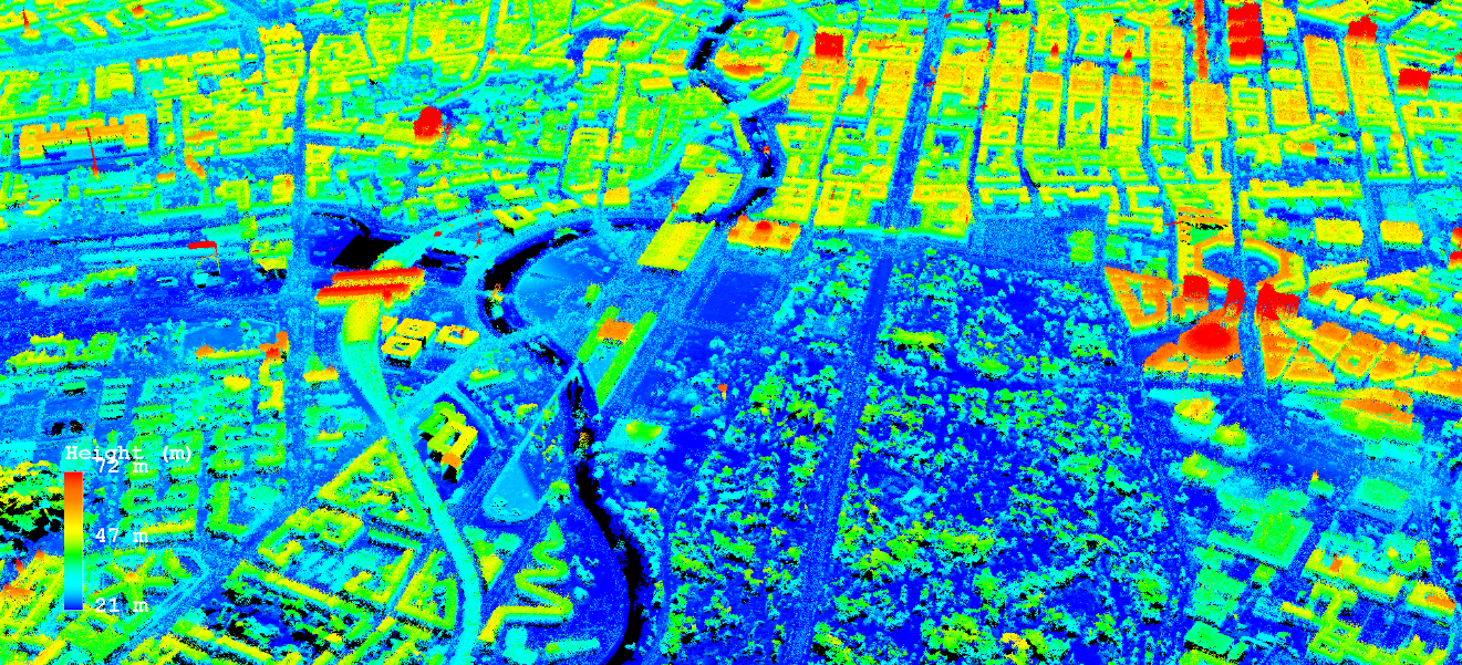 To date, global 3D urban information is inexistent, not even to mention its temporal evolution, i.e. 4D. The state-of-the-art global
digital elevation model (DEM) from the German TanDEM-X mission delivers a DEM of high quality (12 m posting) close to HRTI-3 standard.
However, when it comes to urban mapping, layover effects caused by the side-looking nature of the radar satellites handicap the use of TanDEM-X data
alone for a precise 3D reconstruction in urban areas. The So2Sat project will develop algorithms and methodology to fuse and combine
TanDEM-X data and ground-level data from social networks on a global scale.
The Figure shows a 3D model of Berlin created by fusing the result of SAR interferometry and optical multiview stereo matching.
Behind each of the SAR points, there is also the deformation history with an accuracy up to millimeter.
To date, global 3D urban information is inexistent, not even to mention its temporal evolution, i.e. 4D. The state-of-the-art global
digital elevation model (DEM) from the German TanDEM-X mission delivers a DEM of high quality (12 m posting) close to HRTI-3 standard.
However, when it comes to urban mapping, layover effects caused by the side-looking nature of the radar satellites handicap the use of TanDEM-X data
alone for a precise 3D reconstruction in urban areas. The So2Sat project will develop algorithms and methodology to fuse and combine
TanDEM-X data and ground-level data from social networks on a global scale.
The Figure shows a 3D model of Berlin created by fusing the result of SAR interferometry and optical multiview stereo matching.
Behind each of the SAR points, there is also the deformation history with an accuracy up to millimeter.
Building Type and Settlement Classification
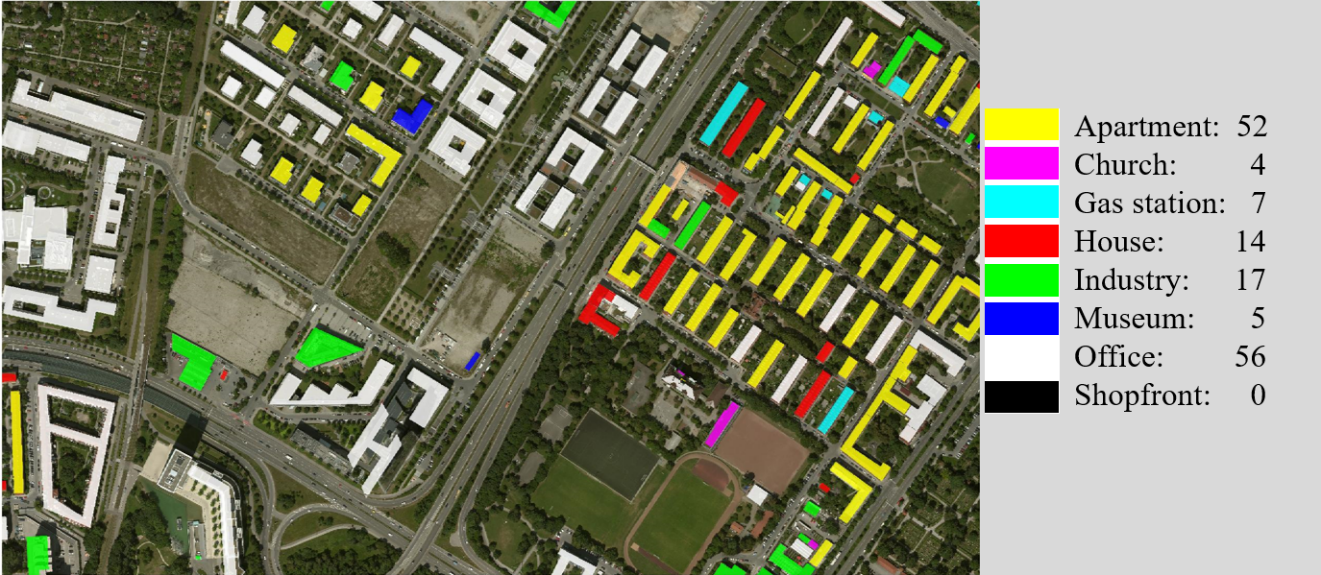
The So2Sat project is aiming at better building type and settlement type classification integrating many sources of information ranging from satellite and aerial imagery over street level images to social media information. The image depicts an example of settlement type classification of individual building instances. The So2Sat project will focus on the residential, commercial and mixed-use classes.
Local Climate Zone Classification
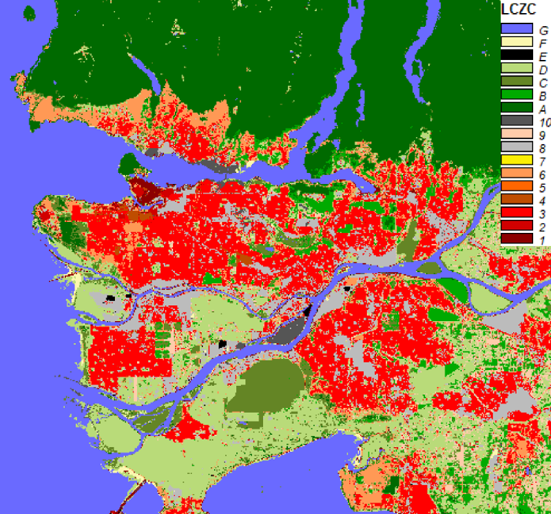
The description of the physical structure of cities has long been a highly diverse topic. Many results on urban climatology including associated terminology was not easily transferable between different city types and cultures. Bootstrapped by work from Stewart and Oke [1, 2], research has agreed on a common scheme of classifying the physical appearance of cities with a scheme of 17 discrete classes capturing combinations of height, density, and surface cover.
As this classification scheme has seen a wide adoption in urban climatology, the So2Sat project is going to apply its methodology in order to produce LCZ classificatoin from remote sensing data in large scale.
High resolution population density map
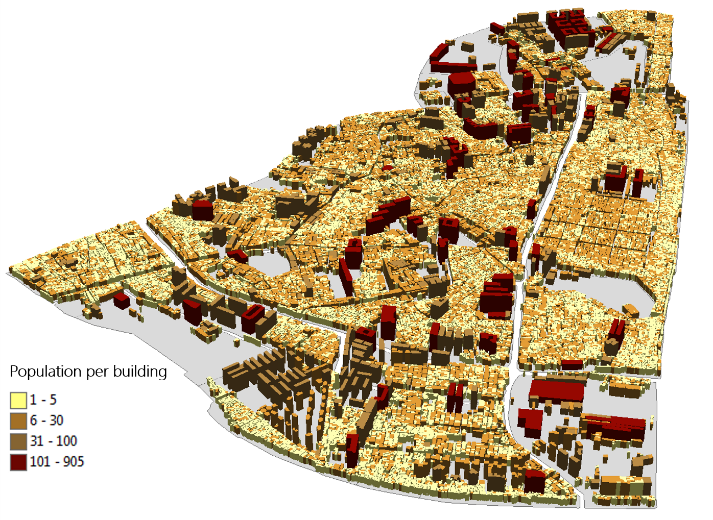 Almost every study dealing with population data from national to global scales relies on the data published by the
United Nations or from LandScan. The database is globally available, but they are only at a spatial resolution of about 1km,
and with few temporal samples which is not suitable for constant monitoring. So2Sat will seek for significant
breakthroughs in high-resolution and high-quality population estimation.
Almost every study dealing with population data from national to global scales relies on the data published by the
United Nations or from LandScan. The database is globally available, but they are only at a spatial resolution of about 1km,
and with few temporal samples which is not suitable for constant monitoring. So2Sat will seek for significant
breakthroughs in high-resolution and high-quality population estimation.
The figure to the right provides the estimated building-level population in a slum area in Mumbai. With the So2Sat project, we aim to extend such analysis to a wide range of cities and building types.
Localization of informal settlements
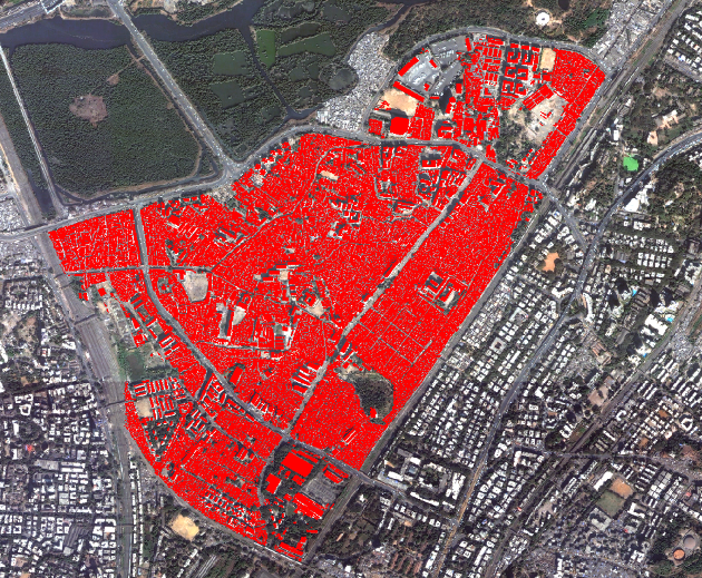 Currently, the spatial layout of informal settlements within the wider urban context is generally subject to descriptive
studies in geography. So2Sat will develop a formal ontology to describe the physical characteristics of informal settlements
across the globe. With the capability to globally locate and characterize such informal layouts in cities, a unique spatial
knowledge will be available to tackle the more specific question of the amount of slum dwellers, where extrapolation methods
will be developed. The image depicts a slum area in Dharavi, Mumbai mapped by remote sensing data.
Currently, the spatial layout of informal settlements within the wider urban context is generally subject to descriptive
studies in geography. So2Sat will develop a formal ontology to describe the physical characteristics of informal settlements
across the globe. With the capability to globally locate and characterize such informal layouts in cities, a unique spatial
knowledge will be available to tackle the more specific question of the amount of slum dwellers, where extrapolation methods
will be developed. The image depicts a slum area in Dharavi, Mumbai mapped by remote sensing data.
References
- Stewart, I.D., Oke, T.R. and Krayenhoff, E.S. 2014. Evaluation of the ‘local climate zone’scheme using temperature observations and model simulations. International Journal of Climatology. 34, 4 (2014), 1062–1080.
- Stewart, I.D. and Oke, T.R. 2012. Local climate zones for urban temperature studies. Bulletin of the American Meteorological Society. 93, 12 (2012), 1879–1900.